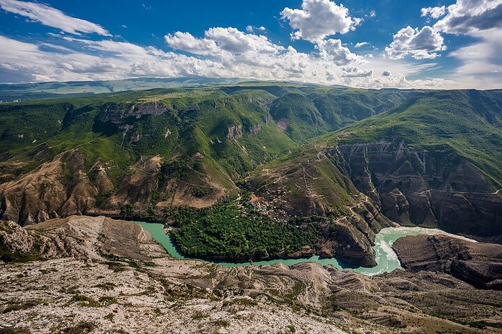
The Sulak Canyon in the Sulak River Valley is the republic's most recognizable natural landmark. Photo: Sobolev Alexander / Wikimedia Commons, CC BY-SA 4.0
Key facts about Dagestan
- The optimal time for mountain routes is May, June and September, for a beach holiday – July and August.
- The recommended trip duration is 7 days: in less time, the highlands and the coast cannot be covered in one route.
- The depth of the Sulak Canyon reaches 1920 meters.
- Derbent is the oldest city in Russia and a UNESCO World Heritage Site: the first settlements on its site date back to the end of the 4th millennium BC.
- For trips through the mountains, you need a crossover or SUV: some of the approaches to the villages are inaccessible to cars.
A snow-capped peak rising 4,142 meters, vines in a subtropical forest, a sheer gorge deeper than Lake Baikal, and a five-thousand-year-old city. All this makes up the Republic of Dagestan, an area of approximately 50,300 square kilometers. Dagestan's attractions stretch from the coastal plain to the highlands, with hundreds of kilometers of serpentine roads in between. It's impossible to see everything in one trip, so the route is tailored to specific interests: mountains, history, or the sea.
In 2020, the republic received 850 thousand guests, and by the end of 2025, Minister of Tourism Emin Merdanov named the figure of 1.98 million — more than doubling in five years. The industry has generated over 20 billion rubles in economic activity. While this doesn't create crowds at the viewing platforms yet, guest houses in Gunib and Chokh are booked up well in advance for August. Each month has its own specialization: May, June, and September are for the mountains, while July and August are for the coast.
Why you should visit Dagestan: mountains, sea, history, and 120 ethnic groups in one place
There are three persistent misconceptions surrounding Dagestan. The first concerns safety: the republic has been welcoming organized groups for years, the relevant ministry operates a 24-hour hotline, and the tourism infrastructure is growing in line with the influx. The second concerns inaccessibility: a flight from Moscow takes about three hours, and flights are operated daily by several carriers.
The third one sounds like “nothing to see” and is broken by geography: in an area of about 50,300 km², there are the ridges of the Caucasus Mountains, a semi-desert, a liana forest, and 530 kilometers of sea coastline.
Another argument is the ethnic composition. Situated in the North Caucasus, the republic is considered the most multinational in RussiaRepresentatives of more than 100 ethnic groups live here, including Avars, Dargins, Lezgins, Kumyks, and Laks, and the number of languages exceeds three dozen. This explains the differences in cuisine, crafts, and architecture between the neighboring valleys.
The objects are conveniently divided into five categories—each worthy of a separate trip:
- Mountains and canyons: the deepest gorge in Europe, observation platforms over turquoise water, the Chirkey Reservoir;
- Waterfalls and forests: Tobot on the edge of the Khunzakh plateau, an underground cascade in the Saltinskaya gorge, the relict Samur forest;
- historical villages: Gamsutl, Goor, Kakhib, Kubachi and Balkhar with living craft traditions;
- Derbent: the Naryn-Kala citadel, fortress walls, Juma Mosque and the Old City under UNESCO protection;
- The Caspian coast: sandy beaches, resort suburbs, and the Soviet ekranoplan "Lun" on the shore.
The choice of month determines half the experience. September wins for a combination of reasons: the flow subsides after the August peak, daytime temperatures remain within comfortable limits, the roads to the villages are open, the trails are dry, and the grapes and fruit are in full bloom.
The best time to visit Dagestan by month
| Period | Weather | Who is it suitable for? |
|---|---|---|
| May - June | In the mountains it's around +20°C during the day, but the sea water is still cool. | For those who are looking for highland scenery, flowering plateaus and a moderate flow of visitors |
| July - August | On the plains it reaches +30°C and above, the sea warms up to +26–28°C | For families with children, sea lovers, and fruit season enthusiasts |
| September | Warm days, cool nights, minimal precipitation in the foothills | For photographers, trekkers, and those who combine mountains and the coast in one route |
In winter, the situation changes. Due to snowfalls and avalanche danger, passes and access roads to villages in the highlands are temporarily closed, and some trails become impassable without equipment. Planning a December or February route along the upper part of the program without a backup plan is not recommended.
Natural attractions of Dagestan: Sulak Canyon, waterfalls, and mountain routes
The Greater Caucasus Mountains occupy approximately 56% of Dagestan's territory, and natural sites are unevenly distributed across it. The Sulak Canyon and the Khunzakh Plateau are a must-see for a first trip; even a short trip can accommodate them. The Saltinskaya and Karadakhskaya Gorges are also recommended. For a second visit, the Samur Forest, Shalbuzdag, and the Tlyaratinsky District nature reserves are reached on separate trips.
Sulak Canyon is the main symbol of mountainous Dagestan
Guidebooks usually list the depth of the Sulak Canyon as 1,920 meters. This is measured from the summit of the mountain rising above the gorge, so the cliff at the edge of which a tourist finds himself is noticeably lower: approximately 1,200–1,550 meters to the water, according to various estimates. The water level of the Chirkey Reservoir also fluctuates by tens of meters depending on the season. By any calculation, this is the deepest gorge in Europe—the Grand Canyon descends approximately 1,857 meters. The canyon's length is 53 kilometers.
The gorge is cut by the Sulak River and is divided into three parts, the largest stretching for 18 kilometers. The drive from Makhachkala is about 100 kilometers and takes about two hours. There are three access points, each offering different experiences: you can visit any of them, or better yet, combine at least two.
Where to go on Sulak:
- to the observation deck near the village of Dubki: from here the entire bowl of the gorge opens up, a shot familiar from most photographs;
- to the Chirkey reservoir, which overflowed after the construction of the Chirkey hydroelectric power station: boats go straight to the sheer walls;
- to the village of Zubutli - the entrance is from below, right next to the water, access is only by SUV;
- to the Nokhyo cave complex with a suspension bridge over the canyon: suitable for those traveling with older children;
- to the Sarykum dune on the way from Makhachkala - the largest sand mountain in Eurasia and a convenient stop before climbing into the mountains.
The water's color changes from turquoise to deep emerald depending on the lighting, time of day, and season: in the spring, the stream becomes turbid from meltwater, but by late summer, it becomes clearer. There are no railings at most viewing platforms, and the cliff edge is crumbling, so it's a good idea to hold children's hands at the edge. The price of a boat ride varies seasonally, so don't rely on last year's prices—the price can be confirmed on site or through the tour organizer.
Samur forest, waterfalls and mountain routes
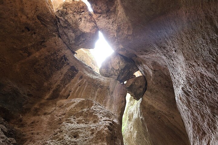
Karadakh Gorge: the passage width in some places is no more than five meters. Photo: Fox121212 / Wikimedia Commons, CC BY-SA 4.0
In the south of Dagestan, on the border with Azerbaijan, the Samur River forms a delta with the relict Samur forest - the only subtropical liana forest in Russia and the northernmost liana forest in the world. The trees here are entwined with vines, orchids are found, and during migration season, the forest is filled with birds.
Tobot Waterfall cascades over the cliff of the Khunzakh Plateau near the village of Khunzakh. Its distinctive appearance has earned it the nickname "Dagestani Niagara." The stream is at its fullest in late spring and early summer, but it dries up by August. Saltinsky Waterfall is hidden within a gorge and falls through a hole carved into the rock—light enters in a narrow column, creating unusual photographs. The water level in the Saltinsky Gorge depends on precipitation: during dry weeks, the cascade dries up.
The Karadakh Gorge, known as the Gate of Miracles, stretches for approximately 400 meters, less than five meters wide in places, and has walls up to 150 meters high. Boulders are trapped between the steep walls, and a narrow strip of light penetrates from above. After rain, the passage is closed due to the risk of flooding.
What else do they see in the mountains:
- Mount Shalbuzdag, 4,142 meters high — a sacred peak to which a pilgrimage route leads;
- Gunib plateau with pine forest, observation platforms and remains of fortifications;
- Irganayskoye Reservoir with turquoise water and terraced apricot orchards along its banks;
- Tlyaratinsky nature reserve in the highlands in the southwest, where trained groups are selected;
- The Chokh terraces are man-made steps on slopes that have been cultivated for centuries.
Serious trekking in this part of the Caucasus requires a local guide: the trails are unmarked, signal is intermittent, and the weather in the mountains can change within an hour. Routes to remote nature reserves and helicopter drops also require permits and approvals, which are easier to obtain through a tour operator.
Historical villages and Derbent: architectural monuments of Dagestan
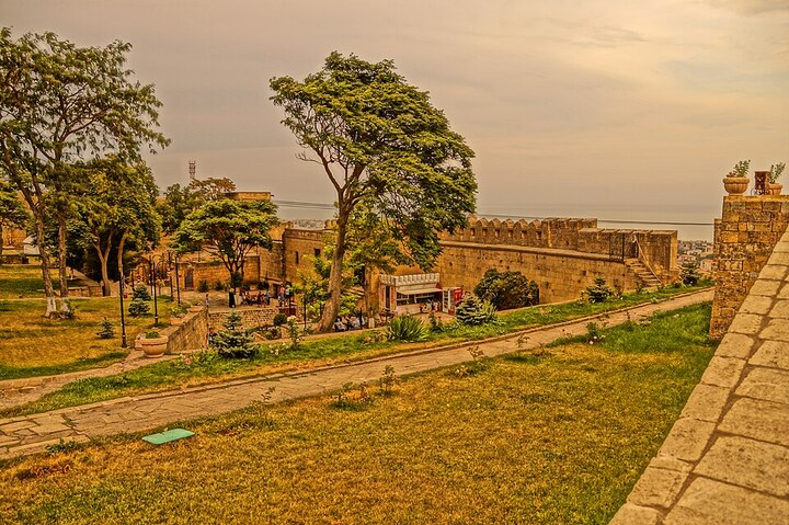
The Naryn-Kala Citadel overlooking Derbent's Old Town. Photo: Moneycantbuy / Wikimedia Commons, CC BY-SA 4.0
The age range of settlements here is enormous: from two thousand years old at the abandoned Gamsutl to five thousand at Derbent. In between are khan capitals, fortresses dating back to the Caucasian War, and villages where craft traditions are still passed down within families.
Derbent is the oldest city in Russia
According to the encyclopediaThe first settlements on the site of Derbent date back to the late 4th millennium BC. In written sources, a fortified settlement in this area appears significantly later—in the 6th century BC. The Naryn-Kala citadel in its current form was built during the Sassanid Empire in the 6th century AD. Along with the fortress walls and part of the Old Town, it is listed as a cultural heritage site. UNESCO World Heritage Site.
The city stands in a narrow passage between the mountains and the sea, about three kilometers wide—hence its strategic importance and the strength of its fortifications. It's possible to see the main sights in one busy day.
What to watch in Derbent:
- the Naryn-Kala citadel with khan's baths, a reservoir and underground structures;
- Derbent wall - the northern and southern parts, which once descended directly into the sea;
- Juma Mosque is one of the oldest functioning mosques in Dagestan;
- Armenian Church of the Holy Savior with a museum exhibition;
- the Old City's mahal quarters with narrow streets and carved gates;
- Derbent lighthouse of the 19th century on the coast;
- Peter I's Cabin is a pavilion above the excavation site of a dugout from the time of the Persian campaign.
Derbent is located at the center of a wine-growing region: vineyards almost reach the city limits, and cognac is produced in Kizlyar, two hundred and fifty kilometers to the north. A glass of wine is paired with chudu—thin flatbreads filled with cottage cheese, herbs, or meat. For breakfast, the coffee shops of the Old Town serve urbech, a thick paste made from ground flaxseed or apricot kernels. Logistically, the city is a convenient final destination: it's close to the airport, and after the highlands, the coast feels like a respite.
Living villages and abandoned ghost villages
Gunib went down in history as the place where on August 25, 1859 (September 6, new style) Imam Shamil's resistance ended, which effectively marked the end of the Caucasian War in Dagestan. Sections of the fortress walls, a historic gazebo, and picturesque observation platforms on the plateau remain. The village is surrounded by pine forest, the air is dry, and the elevation changes on the streets are quite noticeable.
Khunzakh — the former capital of the Avar Khanate, with a history of over two thousand years. At the edge of the plateau stand the remains of the khan's palace and fortress, with the Tobot waterfall cascading down nearby, and a view of the Avar Koysu River opening up from above.
Gamsutl On a mountain ridge in the Gunibsky District of Dagestan, it's the republic's most famous abandoned village. Situated at an altitude of approximately 1,500 meters, it was finally abandoned by its residents in the 2010s. Its resemblance to the Inca city in the Andes has earned it the nickname "Dagestani Machu Picchu." The ascent begins above the village of Chokh: a 2-3-kilometer trail with an elevation gain of approximately 300 meters, the climb takes 40-90 minutes, depending on your pace. There's little shade along the way, so you should set out early in the morning, wearing hard-soled shoes. The walls of the houses are barely hanging on, so entering the buildings and climbing onto the masonry is dangerous.
It's worth setting aside time for Goor — the Goor towers are a medieval defensive complex with a steep observation deck, as well as Old Kakhib With a tower complex on a cliff. Mass migration from the highlands to the plains occurred during the Soviet decades for economic reasons: thus, dozens of half-empty villages appeared on the map, some of which are now gradually being revived by guest houses.
Souvenirs and folk crafts
Craft centers have survived as working factories with constant orders. Buying from a craftsman in the village itself is significantly cheaper than at Makhachkala's markets, and it offers the opportunity to witness the process.
The most common things people bring home from Dagestan are:
- silver and weapon engraving from Kubachi - rings, bracelets, decorative daggers;
- Untsukul wooden products with metal notches on apricot wood;
- Balkhara ceramics, which are sculpted by hand without a potter's wheel;
- Tabasaran handmade carpets with geometric patterns;
- urbech made from flax, apricot kernels or hemp;
- dried fruits, local honey, herbal tea.
Prices for the same item can vary significantly, so it's best to compare in two or three places. The most expensive items are found in tourist shops near observation decks, cheaper in Makhachkala's markets, and significantly better deals are found directly from the artisans. Hand-knotted carpets are the most expensive: each one takes months to make, and the price increases with the tightness of the knot.
Counterfeits regularly appear on store shelves. Stamped imports are sold as Kubachi silver, hand-made carpets are substituted for machine-made ones, and urbech is diluted with sugar and vegetable oil. Genuine silver is hallmarked and noticeably heavier than the alloy. Hand-made carpets can be distinguished by their reverse side—the knot is visible there, and the pattern is the same as the front side.
Dagestani cuisine and the Caspian coast: taste and sea in one trip
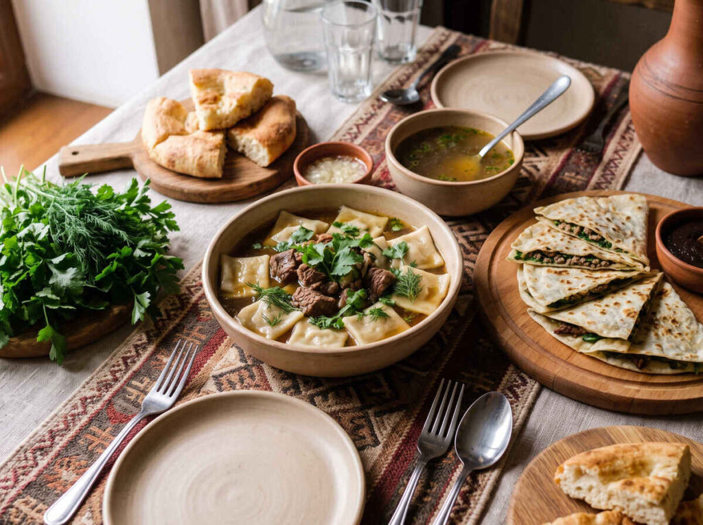
Khinkal, chudu, and urbech are the staples of the local feast. Image created using AI (Nano Banana 2 Pro, Gemini)
The local cuisine is worth considering as a separate reason for a trip. Dagestani khinkal is not related to Georgian khinkali: the word refers to pieces of dough boiled in broth and served with meat, broth, and garlic sauce. The shape of the dough varies by region: Avar khinkal is large and fluffy, Dargin khinkal is rolled into a roll with nuts and herbs, and Lezgin khinkal is rolled thinly.
Main dishes and drinks of local cuisine:
- Khinkal in all regional variations is a basic dish at any feast;
- chudu with cottage cheese, herbs, pumpkin or meat - a thin flatbread with a hidden filling;
- kurze, which resemble dumplings with a braid-shaped closure;
- Urbech made from flax, apricot kernels or hemp - a paste without sugar or additives;
- lamb shashlik and meat cooked over an open fire in guest houses along the route;
- wines of the Derbent Valley and cognac produced in Kizlyar;
- apricots, figs and cherries in season, honey and herbal infusions.
Authentic urbech is sold in villages and markets by weight; its ingredients are limited to ground raw materials. The most interesting dishes are found in family-run guesthouses and roadside eateries, where the menu consists of three or four dishes.
The Caspian Sea: beaches without waves and surf
The Caspian Sea is an endorheic body of water, the largest on the planet, so there are no ocean waves or tides. The water is brackish, and off the coast of Dagestan, it warms up to 26–28°C in July and August. The entry into the sea is shallow, and the bottom is sandy. Makhachkala's city beach has advantages in accessibility but disadvantages in cleanliness and the number of visitors on weekends.
It's calmer in Kaspiysk - he approximately 17 kilometers from MakhachkalaThe shore there is wider, and there are fewer buildings. It's even quieter on the coastal stretches south of Derbent. A unique landmark on the coast is the ekranoplan "Lun," a Soviet ekranoplan approximately 73 meters long, beached near Derbent: one of the most unusual sights in the entire Caspian Sea.
Hotel infrastructure is rapidly developing across the board, but the Caspian coast is experiencing a real construction boom: new modern hotels and resorts open annually in Kaspiysk, Izberbash, and Derbent. Beach vacations have long ceased to be simply an add-on to the mountains—many tourists travel to the republic specifically for the sandy beaches and warm sea, dedicating a full week to the experience.
A 7-day itinerary for Dagestan and practical tips for tourists
A logical plan for a week-long trip: start in Makhachkala via Uytash Airport, travel along the arc of the highlands, and finish in Derbent. Vehicles are selected based on the terrain: a crossover will handle the main routes, but an SUV is needed for Gamsutl and Zubutli, and some access roads require an experienced driver.
Route by days
- Days 1–2. Arrival, accommodation in Makhachkala, the Central Juma Mosque, the Second Market with spices and dried fruits, the embankment, and the first dinner with chudu and shashlik. Afternoon: Sarykum Dune or a trip to the sea: the drive from the city takes a couple of hours.
- Days 3–4. Early departure around 7:00 a.m. to the village of Dubki, a lookout point over the gorge, a boat ride, the Chirkey hydroelectric power station, and a drive to the highlands with an overnight stay in a guest house.
- Days 5–6. Ascent to Gamsutl from Chokh, descent, and transfer to the Khunzakh plateau to the Tobot waterfall. The next day, the Karadakh gorge and Gunib fortress.
- Day 7. Descent through Kubachi with the purchase of silver from the artisans, transfer to Derbent, Naryn-Kala at sunset, dinner in the Old Town.
Driving in the mountains takes longer than GPS devices indicate: switchbacks, road repairs, and gravel sections add 30–50% to the estimated time. For each major location, allow 2–3 hours, including photo breaks.
Logistics, budget and security
Aeroflot, Pobeda, Ural Airlines, S7, and several other carriers operate direct flights from Moscow to Uytash Airport. Flights take between 2 hours 45 minutes and 3 hours. Direct connections are also available to St. Petersburg and other major Russian cities. Tickets are more expensive during peak season, so book in advance. Prices change daily, so please refer to current booking engine results.
Ready-made programs for Dagestan, estimated prices for 2026
Calculating your budget yourself takes time: flights, overnight stays in villages, a car for the switchbacks, a guide on unmarked trails. Transportation is the most expensive, as a car simply won't make it to Gamsutl and Zubutl. individual tours in Dagestan From GO&DO all this is already assembled, the prices below are calculated for a group of four adults.
| Program | Term | Cost per person | What's included |
| Getting to know Dagestan | from 4 days | from 129,000 rubles | Accommodation in hotels, transfers by car and comfort-class minibus, personal guide for all days, boat trip along the Sulak Canyon, Gamsutl and Gunib, Khunzakh and Matlas, Derbent, national lunches |
| The Great Journey | from 7 days | from 179,000 rubles | The same plus Kakhib and Goor, Tobot waterfall, extended program in the villages |
| VIP with helicopter | from 5 days | from 590,000 rubles | Lexus SUV transfers, a Eurocopter H130 helicopter ride, a business lounge meeting, a personalized menu, a national cuisine masterclass, and dinners at top restaurants |
Prices are calculated per person for a trip of four; for a couple or family with a child, the calculation will be different. Programs are subject to change, so please check the current prices and available dates before booking. The difference between packages primarily depends on transportation:
- an SUV with a driver opens access roads that are inaccessible to a passenger car, and the driver himself knows the detours when the road is closed for repairs;
- a helicopter reduces the daytime journey to half an hour and shows the Sulak Canyon, Gunib and Karadakh from above in one flight;
- a boat trip along the Chirkey reservoir takes you to the steep walls of the canyon, where you can’t get down from the shore;
- A rented crossover frees up your schedule, but the condition of the dirt road and parking in the village remain your concern.
The security situation is calm: tourist destinations are patrolled, and visitors are treated with friendliness. Useful numbers include 102 for the police and 112 for the emergency services. The relevant ministry asks people to call its 24-hour hotline. +7 (8722) 52-24-17. In remote areas without communication or signage, independent excursions are not recommended, and border areas require prior verification of access rules: some routes require passes. Insurance for mountain areas includes coverage for active recreation.
Cultural norms
The rules are simple and apply almost everywhere. Islam in Dagestan is a living practice, not a formality, so in mosques and villages, covered clothing is appropriate: shoulders and knees are covered, and women must wear a headscarf. People sit at the table at the invitation of the host; refusing a treat is considered impolite, so it's worth at least symbolically trying what's offered. Drinking alcohol in public is frowned upon in the mountains.
Photographing people begins with a question: older women often refuse, and there's no need to insist. Invitations to homes from strangers are common here and are based on adat—a set of customs that enshrines hospitality as a norm. It's best to avoid religious and political topics in conversation.
Summary: How to Plan a Trip
The final day of the classic route usually ends in Derbent: with an evening stroll through narrow magals and dinner on the shores of the Caspian Sea. By this point, the turquoise waters of the Sulak Canyon, the abandoned houses of Gamsutl, the waterfalls of Khunzakh, and the silver in Kubachi have been left behind. Seven days are plenty for the main attractions, but Shalbuzdag, the Samur Forest, and the highlands south near the border are almost always reserved for the next trip.
There's plenty to worry about before the trip: border zone passes, a car for the switchbacks, a guide on unmarked trails. If you don't want to take on all this yourself, GO&DO has a service. a ready-made individual tour of Dagestan — the tour operator has been operating since 2013 and is included in the unified register.
Frequently Asked Questions
Is it worth going to Dagestan on your own or is it better to take a tour?
Both options are viable. A solo trip is suitable for experienced drivers prepared for winding roads and dirt roads. This organized format saves time on logistics, eliminates permit issues, and provides access to locations difficult to reach without a local escort.
How many days does it take to get to know someone properly?
A minimum of seven days: two for the plains and the coast, four for the mountain range, and one for Derbent. Five days will provide a shortened itinerary without the remote villages. Ten days allow for the addition of the Samur Forest and the south of the republic.
Is it safe to travel in Dagestan?
Tourist destinations are quiet, with tourist numbers increasing annually. The ministry operates a 24-hour hotline. The main risks are related to roads and terrain: switchbacks, unguarded cliffs, and mountain weather. Remote areas are accessible with a guide, while border zones require access control.
What food should you definitely try?
Khinkal in Avar and Dargin varieties, chudu with cottage cheese or meat, kurze, urbech made from flax or apricot kernels. For drinks, try wines from the Derbent Valley and Kizlyar cognac. The most memorable experiences are usually left by family-run guesthouses and roadside eateries.
Which attractions are suitable for families with children?
The Dubki observation deck, boat ride, Sarykum Dune, Derbent's Old Town, and Naryn-Kala are all easy to navigate. The climb to Gamsutl requires reasonable fitness and is suitable for children aged around eight years and up. There are no railings along the cliffs, so supervision is constant.
Do you need a permit to visit the mountainous areas?
Most popular attractions don't require a permit. Restrictions apply in the border zone in the south of the republic: permits are issued in advance, and the process can take several weeks. Rules are subject to change, so please confirm access details with the border control office or the organizer before your trip.
Where is the best place to spend the night during a mountain trek?
The ideal base is the guesthouses in Gunib, Chokh, and Khunzakh: they're close to the main points of interest and don't require a return trip to the capital. Comfort levels vary, and hot water and heating aren't available everywhere. During peak season, rooms are booked in advance.
Sources
- RIA Dagestan. Dagestan welcomed approximately 2 million tourists in 2025 // Tourism and Events. – January 28, 2026. riadagestan.ru
- Khvatova Ya. Population of Dagestan: Number, Density, Peoples // This is the Caucasus (TASS). - December 25, 2024. etokavkaz.ru
- Samur forest // Wikipedia. ru.wikipedia.org
- Shalbuzdag // Wikipedia. ru.wikipedia.org
- Derbent // Wikipedia. ru.wikipedia.org
- Citadel, Old Town and Fortifications of Derbent // UNESCO World Heritage Centre. — Year of inscription: 2003. Criteria: III, IV. whc.unesco.org
- Capture of Gunib // Wikipedia. ru.wikipedia.org
- Distances and routes // Autodispatcher. avtodispetcher.ru
- TASS. A hotline for tourists has been opened in Dagestan in connection with the situation at Makhachkala Airport. // Society. – October 30, 2023. tass.ru